Wilmington is working toward its plans for 2030 with a redesigned Fifth Avenue and land purchased for a future neighborhood park. Other improvements, such as a continuous Greenville Loop Trail and a new downtown trail, have more steps to clear. Housing investment is documented, but the published funding count doesn’t tell residents how many additional affordable homes are ready to live in.
The city has made progress on identifiable milestones. Whether those changes will make Wilmington easier to live in depends on completing the connections between projects and measuring what happens afterward. A street project can be finished before its effect on safety is known, and an adopted neighborhood plan can contain years of work that still needs money.
That distinction follows naturally from our look at nine Wilmington community surveys. Residents have repeatedly identified housing and traffic as concerns. The forward-looking question is how the city’s plans address those problems, and what residents should expect to see next.
What the 2030 plan promises
The strategic plan covers housing and neighborhoods, transportation and infrastructure, public safety, city operations, and economic development and culture. Its initiative matrix contains 15 objectives and 45 initiatives across those five areas. The brochure presents the same framework in a shorter format.
Some commitments are specific enough to recognize when they happen, such as completing the Greater Downtown Plan. Others describe continuing work, such as reducing violent crime, expanding housing opportunities or improving city customer service. Many don’t identify a numerical target or an individual completion date.
The city describes the plan as 2025–2030, adopted in February 2024; the PDF labels it FY25–FY30. Wilmington is already in fiscal year 2027, which began July 1, 2026. The end of the strategic-plan period is a planning horizon, and it doesn’t make every project mentioned in these documents a guaranteed opening by 2030.
What has happened and what comes next
The eight cases below connect major plan priorities with published project or program records checked October 13, 2026. The selection covers eight cases within a framework of 45 initiatives. Each has a different test of progress, so counting an adopted policy and a completed street as equally finished would hide more than it explains.
Eight selected cases show different stages of progress
| Selected case | Documented stage | Next test | Timing |
|---|---|---|---|
| Greater Downtown Plan adoption | Completed milestone | Fund and implement actions | Adopted June 2026 |
| Fifth Avenue construction | Completed milestone | Track use and safety | Completed late 2025 |
| Greenville Loop park land | Completed milestone | Design and fund amenities | Opening date not stated |
| Greenville Loop Trail | Partial delivery | Open continuous connections | Section forecasts need updates |
| Downtown Trail phase 1 | Planning / funding | Secure construction funding | No opening date stated |
| Vision Zero policy | Completed milestone | Evaluate treatments; develop action plan | Next steps expected winter 2027 |
| Affordable rental support | Output reported | Report delivery and affordability | Current housing plan ends June 2027 |
| Riverwalk maintenance | Partial delivery | Report current work and access | Multiyear effort |
- Completed milestone
- Partial delivery
- Planning / funding
- Output reported
The clearest completed milestones are the Greater Downtown Plan’s adoption, Fifth Avenue’s construction and the Greenville Loop park land purchase. Each advances a larger goal. None establishes by itself that housing costs have eased, traffic has improved or a new park is ready for visitors.
Downtown has a plan, with implementation still ahead
City Council adopted the Greater Downtown Plan on June 16, 2026. It covers 18 neighborhoods around the downtown core and incorporates input from more than 6,300 participants. That fulfills the strategic plan’s commitment to complete a downtown plan, while beginning a much longer implementation effort.
The implementation chapter connects housing with the everyday needs of a neighborhood. Its proposed actions include reducing zoning barriers to smaller housing types, using public land for affordable housing and attracting more everyday services. Other actions address local businesses and the ease of opening one. Mobility proposals include making it easier to park once and continue on foot, and helping service workers get to work affordably.
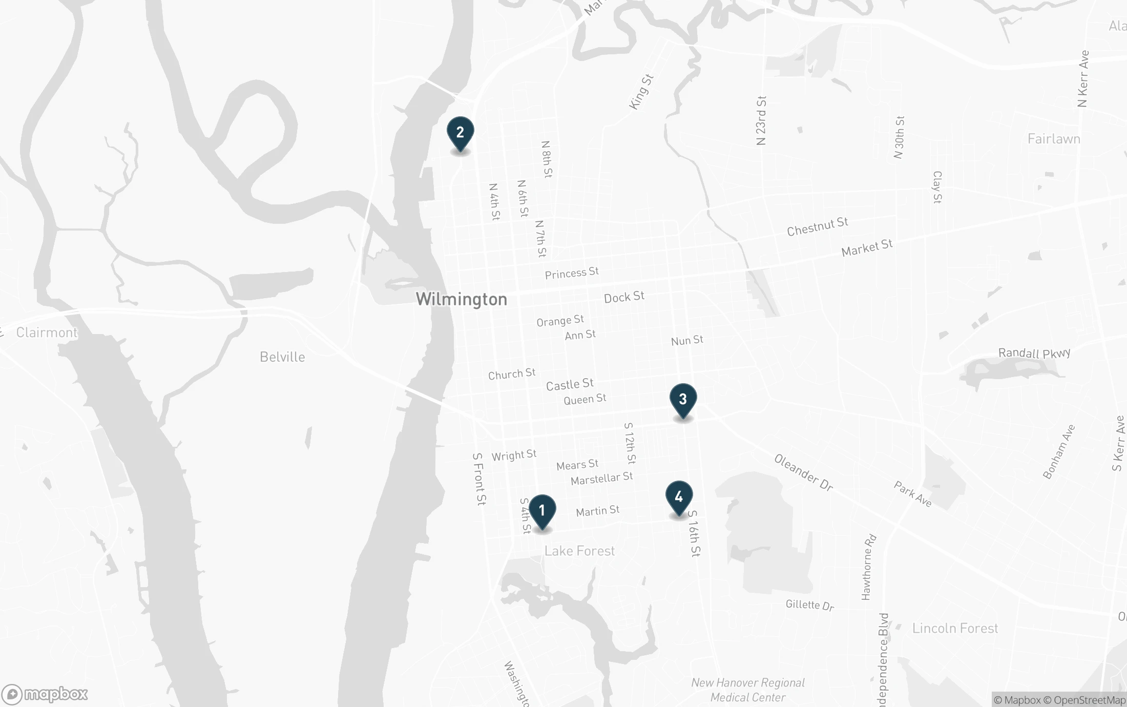
The plan also gives its neighborhood goals a geographic focus. Four example redevelopment scenarios show where housing, local services and better connections could be combined.
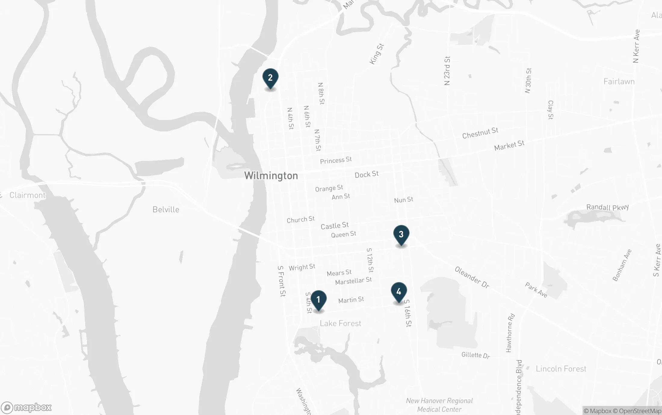
Numbered pins locate general focus areas, not individual parcels. View the full-size downtown map. Basemap: © Mapbox © OpenStreetMap.
Four places where the plan brings its priorities together
- 1Greenfield Street at South Fifth Avenue
Near the South Front District and Greenfield Lake, the scenario combines smaller housing types, apartments above shops, adaptive reuse, improved crosswalks and a Fifth Avenue bikeway.
- 2Northern Riverfront and Brooklyn Arts District
Underused sites could connect Riverfront Park, the Convention Center, Cape Fear Community College and the Riverwalk. Examples include active ground-floor uses, apartments, alley improvements and a festival retail street on Bladen Street.
- 3Delgado Gateway
Around Dawson Street and the 16th and 17th street corridors, the scenario reconnects streets and pairs affordable housing and mixed-use buildings with retail, open space and trail connections.
- 4Medical District Gateway
Around Greenfield Street and the Houston Moore community, the scenario includes housing, small-scale services, green space, school-campus expansion and a greenway toward the Medical District.
Those details matter because a growing downtown can remain inconvenient for the people who live or work there. More housing helps differently depending on its price and proximity to necessities; a new destination helps differently depending on whether workers can reach it.
The chapter assigns anticipated timing bands of zero to two years, two to five years and five to more than 10 years, alongside an in-progress category. It also says projects requiring dedicated funding must go through the city’s Capital Improvement Program. Some of the neighborhood vision therefore extends beyond the 2030 strategic-plan horizon. The timing bands describe expectations, not guaranteed dates for construction.
There are signs of implementation activity. The city’s procurement listings include July 2026 solicitations for downtown urban design, placemaking and public space, and market feasibility and economic analysis. These document efforts to obtain services; a listing marked pending doesn’t establish that a contract has been awarded. The next useful test is which actions receive adopted funding and which policies take effect.
The trail network depends on the missing connections
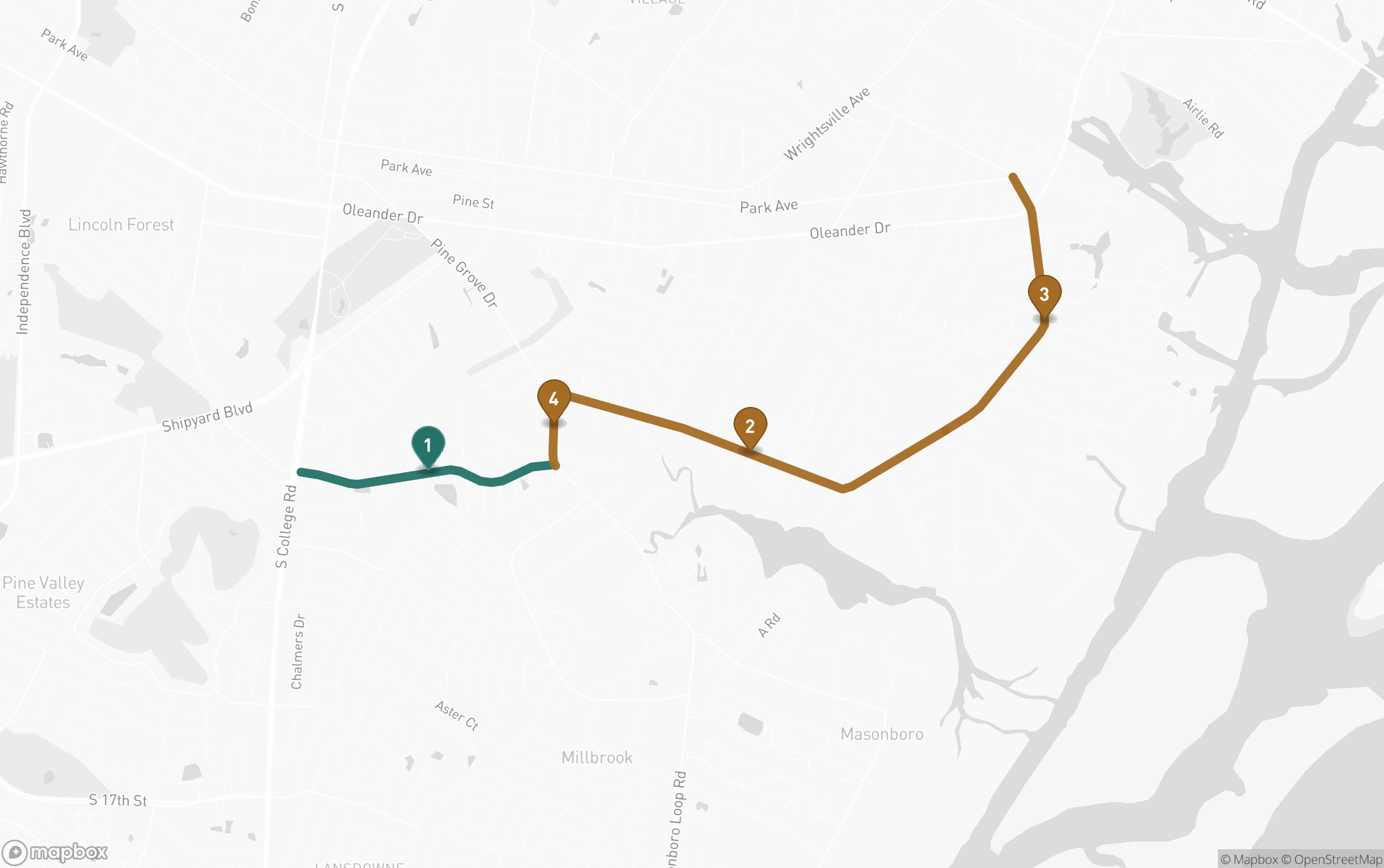
The Greenville Loop Trail is planned as a 4.4-mile route connecting schools, neighborhoods and shopping areas in southeastern Wilmington. Its route would link the Central College Trail with the River-to-Sea Bikeway through Holly Tree Road, Pine Grove Drive and Greenville Loop Road.
The city split it into four sections. The Holly Tree section was completed in 2023, and the project page lists $3.86 million for phase two. Other sections have separate schedules, including one tied to the Pine Grove Drive intersection work. A completed section is useful, but the wider transportation benefit depends on whether the next section reaches a destination or another usable route.
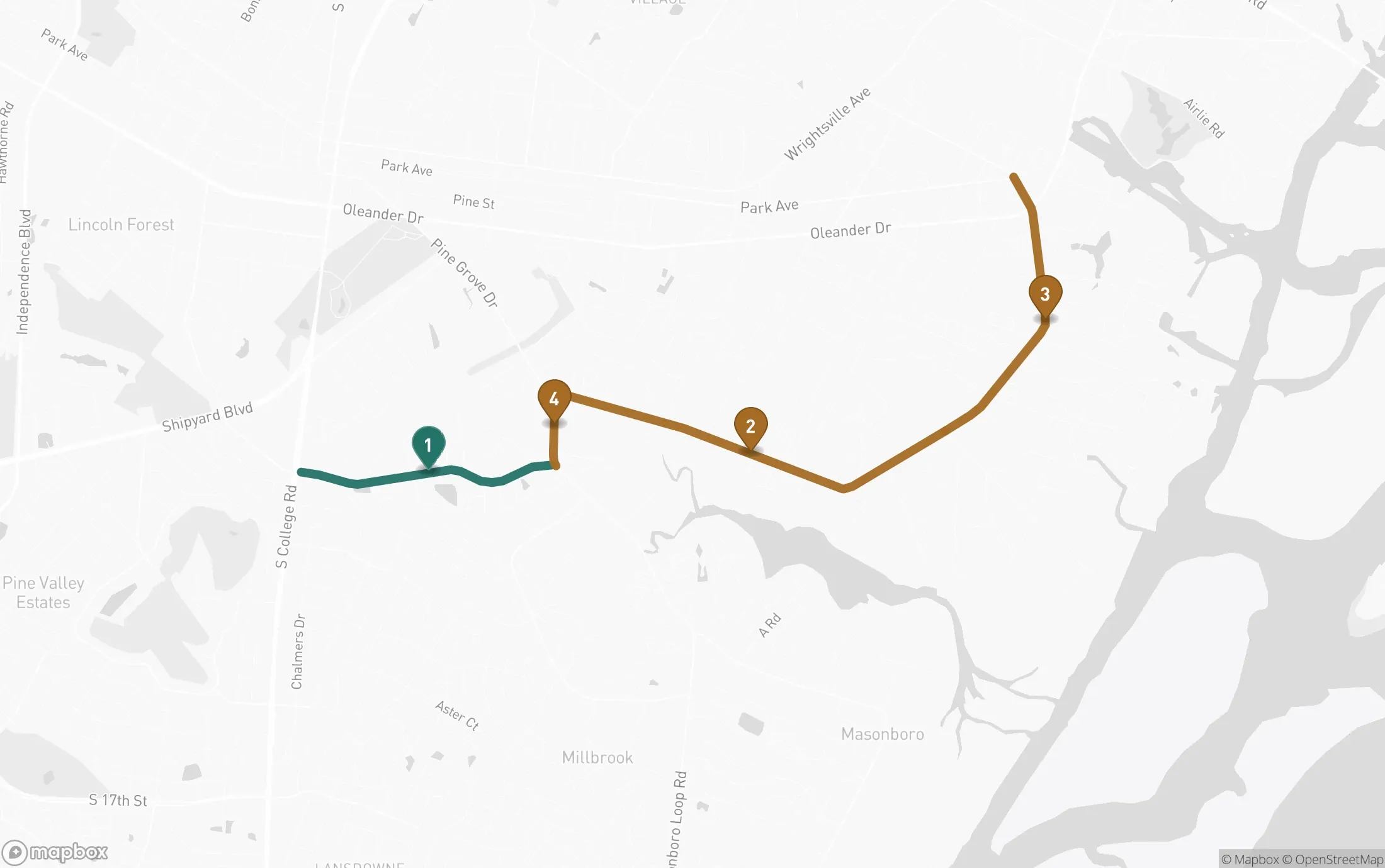
Green shows the Holly Tree section completed in 2023; gold shows the remaining planned corridor. The route follows city GIS paths and road centerlines for orientation, rather than exact future trail placement. View the full-size trail map. Basemap: © Mapbox © OpenStreetMap.
The connection runs through sections 1, 4, 2 and 3
- 1Holly Tree Road: College Road to Pine Grove Drive
Completed in 2023, shown in green. This is the western connection toward the Central College Trail.
- 4Pine Grove Drive: Holly Tree Road to Greenville Loop Road
This short connecting section is coordinated with the planned Pine Grove Drive and Greenville Loop Road roundabout.
- 2Greenville Loop Road: Pine Grove Drive to Old Military Road
The project page lists a fall 2025 start forecast and $3.86 million for this phase. That forecast doesn’t establish its current completion status.
- 3Old Military Road to Park Avenue
The corridor continues along Greenville Loop Road and Greenville Avenue toward the River-to-Sea Bikeway. The page’s early 2026 start forecast also needs a current update.
Several schedules on the page still refer to starts in fall 2025 or early 2026. Those forecasts are insufficient to establish the current state of every section. For someone planning a school commute or a bike trip, the relevant milestone is an announced opening of a continuous connection. No single completion date on the page guarantees the entire 4.4-mile route is available.
The Wilmington Downtown Trail is at an earlier stage. Its proposed first phase is 1.7 miles from Third Street to the Love Grove Memorial Bridge, including a half-mile along the former Atlantic Coast Railway corridor. The city says that phase is being designed and construction funding is being sought. A feasibility study for phases two and three was adopted by the WMPO board in 2025.
That is documented planning progress. Construction funding and a usable connection remain the next milestones. The page’s conceptual imagery includes possible future passenger rail, but it explicitly says no passenger-rail construction project is funded in that area.
The strategic plan also commits to completing the 2014 transportation-bond projects. Voters approved $44 million, supplemented by local funding to a $55 million allocation. Some work supporting the city’s future therefore comes from commitments made more than a decade ago. The plan’s reference to a potential 2026 transportation referendum is a commitment to evaluate that option, not evidence that a new bond passed.
Housing needs a delivery count alongside the funding count
The city’s housing-plan page reports more than 800 rental units funded over the current consolidated plan’s life and more than 30 households supported with first-time homebuyer loans or down-payment assistance. Those figures document program activity, but they describe different forms of support.
The city reports more than 800 rental units funded
Rental units funded over the life of the current consolidated plan.
The reported total does not separate preserved units, new construction or completed and occupied homes.
The rental figure needs a delivery breakdown before it can answer how many more affordable homes residents can use. Funding can support new construction or preservation of existing housing, and projects can receive commitments before completion. Preserving an affordable apartment matters, but it has a different effect on total supply from building another one.
A useful housing assessment would follow the same group of funded projects through units preserved, under construction and completed, with affordability periods and income eligibility attached. Household cost burden and the supply of available affordable rentals would then help show whether program activity is easing the wider problem. Adding unlike counts, or counting the same development again at every stage, would overstate progress.
There is a near-term policy checkpoint. The current consolidated plan ends June 30, 2027, and the city is preparing its next plan for FY2028–FY2032. That process will set housing and community-development priorities while the broader strategic plan is still underway. Specific delivery targets and reporting would make future assessments more useful than a growing funded-unit total alone.
A new park starts with land and needs a separate building budget
Wilmington reports that it has purchased 25 acres off Greenville Loop Road for a future park. The property is adjacent to Bradley Creek Elementary School, and its connection with the trail corridor gives the acquisition a practical neighborhood purpose.
The $9.75 million purchase combines city and county contributions with substantially larger outside funding. The Endowment supplies about 79.5% of the acquisition amount.
Outside funding supplies most of the park land purchase
- The Endowment$7.75 million79.5%
- City of Wilmington$1 million10.3%
- New Hanover County$1 million10.3%
Buying the land protects the opportunity to create a park. The city says specific amenities will be shaped through public planning, with development potentially occurring in phases according to funding and community input. The acquisition amount doesn’t establish that construction of the amenities is funded, and the project page doesn’t promise an opening date.
This is a completed land-purchase milestone with design and delivery still ahead. Residents should be able to see those stages separately rather than having the whole project labeled either finished or untouched.
Street safety needs an outcome test
Wilmington adopted Vision Zero in September 2025, with a goal of eliminating traffic deaths and severe injuries by 2036. The city’s baseline explains why walking and cycling need particular attention. It reports 121 traffic deaths from 2015 through 2024, with pedestrians and cyclists representing a much larger share of deaths than of collisions.
Pedestrians and cyclists represent a larger share of deaths
Shared scale: 0 to 100%
The percentages have different denominators. They show the disproportionate fatality share within the city’s reported crash data; they don’t establish an individual traveler’s risk or a fatality rate for walking compared with driving.
The city scheduled neighborhood traffic-calming construction for March through October 2026, with data collection beginning in fall 2026. Listed locations include Rogersville Road, Charter Drive, Burnett Boulevard and other neighborhood streets. Recommended next steps are due to City Council by winter 2027.
This creates a useful test during the strategic-plan period. Installation records can establish where improvements were made, while before-and-after speeds and longer-term serious-crash trends can show whether they are helping. A short period without a crash is insufficient to establish a lasting safety effect. The 2036 goal also needs to remain visible as a longer-term commitment, rather than being mistaken for a 2030 deadline.
The bridge forecast assumes a different Fifth Avenue
The Fifth Avenue improvement project, completed in late 2025, gives a concrete example of the city’s multimodal goals. Between Market and Greenfield streets, the work included new bicycle lanes and sidewalk repairs, with one driving lane in each direction and curbside parking retained. Water and sewer replacement was coordinated with the street work.
Its $15.75 million total includes $12 million paid by CFPUA for water and sewer infrastructure. The whole amount shouldn’t be described as bicycle spending or counted as solely a city-funded transportation investment.
Nearby, NCDOT is leading the Cape Fear Memorial Bridge replacement, estimated at $1.1 billion. A $242 million federal grant was awarded in 2024, but that grant is only part of the project’s funding story.
The bridge analysis makes coordination with local streets particularly consequential. NCDOT’s environmental assessment, Table 12 on printed page 36, models four through lanes on two Fifth Avenue segments under Alternative B’s future conditions. The assessment’s text describes an increase from two lanes to four.
Fifth Avenue’s built configuration differs from forecast assumptions
| Record / scenario | Through lanes | What the record establishes |
|---|---|---|
| Completed Fifth Avenue project | 2 total | One driving lane each way; bicycle lanes added |
| EA Table 12 base conditions | 2 total | Wooster–Castle and Castle–Church segments |
| Alternative B, no toll | 4 total | Future assumption on those two segments |
| Alternative B, toll | 4 total | Future assumption on those two segments |
Read each cell for the documented configuration or project stage.
Those are assumptions used in a 2050 traffic forecast. They aren’t a final instruction to remove bicycle lanes or a prediction of the street’s configuration in 2030. But the city’s published response raises the discrepancy with its recent bicycle investment. The issue is whether the regional analysis and eventual design account for the street Wilmington has built and its neighborhood goals.
The city’s bridge timeline anticipates selection of an alternative in late 2026 and environmental approval in winter 2027; right-of-way acquisition and construction remain listed as TBD. A decision about the bridge’s design will be significant progress in planning, while a promised opening by 2030 would go beyond that published schedule.
Maintenance and staffing also determine what gets delivered
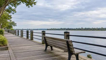
Maintaining existing infrastructure is one of the strategic plan’s commitments, and the Riverwalk decking-replacement project shows how that work affects a place residents and visitors already use. Contractors began a multiyear effort on the 1.75-mile route in spring 2025. By June that year, approximately 1,000 linear feet of decking had been replaced before the summer pause.
The route includes different structures, so dividing that output by the entire Riverwalk length would give a misleading completion percentage. The page also lists $295,000 for an annual project, which doesn’t establish the entire multiyear cost. Separate work to raise a concrete section near the marina required a revised engineering approach after grout injection proved ineffective.
The strategic plan’s proposed northern extension has a different status again. It calls for assessing feasibility findings and identifying construction-funding options. Maintaining the current promenade and considering an extension are separate commitments. For a walk today, our Wilmington Riverwalk guide covers the existing route.
City operations matter alongside the visible projects. The adopted FY27 budget totals $349.8 million and includes a living-wage strategy to support recruitment and retention. The city says more than 70% of increased investments support police and fire; that is a share of the increase, not of the entire budget. Council also approved $2,504,978 from available fund balance for one-time police vehicles and equipment.
These are documented funding decisions supporting safety and workforce goals. Staffing vacancies, retention and service performance would help establish what residents receive from them. Budget totals alone can’t do that, especially when the city cautions that organizational changes affect comparisons between years.
The next milestones to watch before 2030
The upcoming decisions are unevenly scheduled. Some have published expectations in 2027, while other projects are seeking money without an opening date. The timeline below separates those expectations from the plan’s broader horizon.
Published checkpoints extend from late 2026 beyond 2030
- Fall 2026: scheduled safety evaluation
City plans to begin traffic-calming data collection. Installation records and measured speeds are the next evidence of delivery and effect.
- Late 2026: expected bridge alternative selection
The city’s NCDOT project timeline anticipates a design alternative decision; it does not establish a construction start.
- Winter 2027: expected action and environmental decisions
Vision Zero recommended next steps are due to Council; the bridge timeline anticipates environmental approval. Both remain published expectations.
- July 2027: next housing-plan period
FY2028–FY2032 follows the current consolidated plan, which ends June 30, 2027. Watch adopted priorities and specific delivery targets.
- Through 2030: strategic-plan horizon
Evaluate connected routes, housing delivery and resident outcomes. Some downtown actions have 5–10+ year timing bands; trail and park openings depend on project funding and schedules.
- 2036: longer-term traffic-safety goal
Vision Zero aims to eliminate traffic deaths and severe injuries. This target lies beyond the FY25–FY30 strategic plan.
Schedule clarity also deserves attention. The Dawson and Wooster project page forecasts construction from March 2026 to March 2027, yet the city also lists a July 2026 construction rebid. The project page reports a $5,762,423.15 construction contract award and links a groundbreaking video, which document progress. Those records don’t reconcile the construction timeline after the rebid, so the original forecast alone doesn’t establish that the work is on schedule. They also don’t establish the cause or length of a delay.
The strongest assessment supported by these records is that Wilmington has completed several enabling milestones and funded ongoing priorities, while important connections and outcome tests remain ahead. Downtown adoption, land acquisition and street construction are tangible progress. Housing affordability and safer travel require additional evidence about results, and some projects still depend on future funding or regional decisions.
The survey trends provide a complementary measure of whether residents feel those improvements. A future survey can show changes in satisfaction, while delivery records establish what was done. Neither measure alone explains the other. By 2030, the useful test will be whether people can find suitable housing and reach everyday destinations more easily, with completed projects and reported outcomes that support the city’s assessment of its progress.